_
Lets work together
Nibelungen Bridge
Client
MKP
Industry
Public Company
Expertise
Digtial Exploration & Digital Twins
About
A compact digital twin for the large and historic Nibelungen Bridge on the Rhine. As part of the European research initiative SPP100+, a historic bridge structure - expanded multiple times and partially destroyed over its lifetime - was examined as a pilot project. Rather than digitally mapping the entire structure in full from the outset, the project deliberately focused on a clearly defined pilot area. This smaller digital twin made it possible to demonstrate the overall system in a practical, manageable way.
Overview
Challenge
Outcome
Architecture
Functionality
Approach
_
Why Start with a Pilot Area?
Like people, buildings and bridges tend to age disproportionately over time. As structures grow older, infrastructure management becomes more demanding, more complex, and more costly.
A digital twin offers a better way to meet this challenge - making data easier to access, understand, and use in a targeted way.

_
A Scalable Framework for Digital Twins
All project data was linked directly to the structure and organized in a consistent way. The framework developed up to that point was successfully tested both in the rollout of digital twins and in its transfer to other structures.
Compared with the first digital twin created for this client, the time needed to build this new digital twin was reduced to just 13.3%. The previously developed Digital Twin Core Framework could be transferred directly to the new project.
This showed that once a solid framework is in place, digital twin development can become significantly faster and more scalable.

_
Extending the Framework
The framework was further enhanced with prototype functions for new types of object linking.
In addition to Point of Interest and Structure of Interest functions - such as drilling down into 3D building components - the project also tested an Area of Interest approach.
This allowed the client to define and visualize spatial relationships independently of the original BIM planning. In other words, relevant areas could be selected and displayed based on actual use cases, not just predefined model logic.
Geometries remain hidden until selected, allowing users to focus only on the information that matters in the moment.
By embedding these areas in the data model and transferring them in a separate IFC file, spatial zones could be defined independently from the original model and enhanced with their own visualization functions.

_
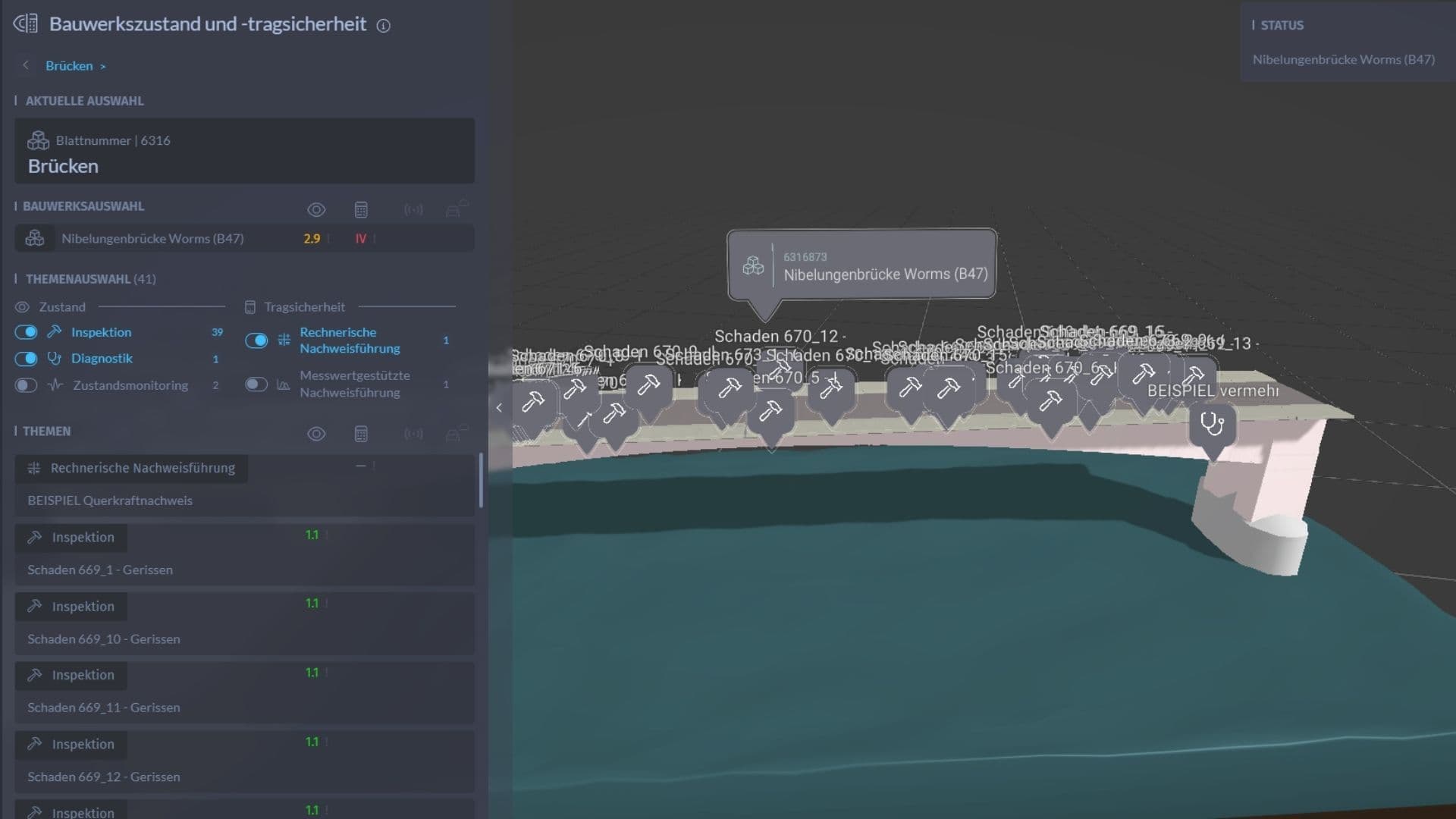
Exploring Data in the Model
The model environment combines a BIM or CDE viewer with the Digital Twin Core Framework and a simplified surrounding context model.
A topic filter allows users to choose which data sources they want to display with just a few clicks. This makes it easy to switch between different information layers and focus on what is relevant.
For one selected spatial model area, 41 datasets are currently available across the chosen topics.
A Point of Interest can show location-based information such as current traffic or weather data. Markers in the model indicate where information is available. If data exists, it becomes visible. If no data exists, nothing is shown.
This creates a simple and intuitive form of data-driven visualization.

_
Start with the Right Scope
A successful digital twin project does not have to begin at full scale. Starting with a clearly defined area can be the smartest way to create value quickly, test workflows, and build a scalable foundation for future development.
Contact
Lets Build Something Together

Lets Build Something Together